Translate

Saturday, November 7, 2015


I have this greeting card for sale to raise funds for CANCER RESEARCH you will find many other gifts on the site for sale to raise funds for Cancer  on this link 

  http://www.zazzle.com/galah_greeting_card-137801476347685135?design.areas=%5Bcard_5x7_outside_print_front%2Ccard_5x7_inside_print_side2%2Ccard_5x7_outside_print_back%5D&rf=238750218790449363

Saturday, November 30, 2013

Church in Falmouth Cornwall


I found this church in Falmouth in 2007 I did not have the time to find out any thing about it hope some one will have some info on this church.

Tuesday, November 26, 2013

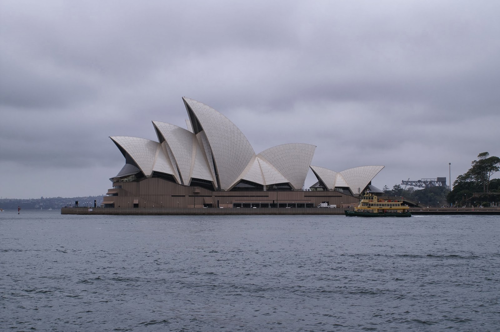
Magnificent Sydney Opera House


The Sydney Opera House is a multi-venue performing arts centre in Sydney, New South Wales, Australia. Situated onBennelong Point in Sydney Harbour, close to the Sydney Harbour Bridge, the facility is adjacent to the Sydney central business district and the Royal Botanic Gardens, between Sydney and Farm Coves.
Designed by Danish architect Jørn Utzon, the facility formally opened on 20 October 1973[3] after a gestation beginning with Utzon's 1957 selection as winner of an international design competition. The NSW Government, led by Premier Joseph Cahillauthorised work to begin in 1958, with Utzon directing construction. The government's decision to build Utzon's design is often overshadowed by circumstances that followed, including cost and scheduling overruns as well as the architect's ultimate resignation.[4]
Though its name suggests a single venue, the project comprises multiple performance venues which together are among the busiest performing arts centres in the world — hosting over 1,500 performances each year attended by some 1.2 million people. The venues produce and present a wide range of in-house productions and accommodate numerous performing arts companies, including four key resident companies: Opera Australia, The Australian Ballet, the Sydney Theatre Company and the Sydney Symphony Orchestra. As one of the most popular visitor attractions in Australia, more than seven million people visit the site each year, with 300,000 people participating annually in a guided tour of the facility.[5][6]
Identified as one of the 20th century's most distinctive buildings and one of the most famous performing arts centres in the world,[7][8][9] the facility is managed by the Sydney Opera House Trust, under the auspices of the New South Wales Ministry of the Arts.
The Sydney Opera House became a UNESCO World Heritage Site on 28 June 2007.[10]

The facility features a modern expressionist design, with a series of large precast concrete "shells",[11] each composed of sections of a sphere of 75.2 metres (246 ft 8.6 in) radius,[12] forming the roofs of the structure, set on a monumental podium. The building covers 1.8 hectares (4.4 acres) of land and is 183 m (600 ft) long and 120 m (394 ft) wide at its widest point. It is supported on 588 concrete piers sunk as much as 25 m (82 ft) below sea level.
Although the roof structures are commonly referred to as "shells" (as in this article), they are precast concrete panels supported by precast concrete ribs, not shells in a strictly structural sense.[13] Though the shells appear uniformly white from a distance, they actually feature a subtle chevron pattern composed of 1,056,006 tiles in two colours: glossy white as well as matte cream. The tiles were manufactured by the Swedish company, Höganäs AB, which generally produced stoneware tiles for the paper-mill industry.[14]
Apart from the tile of the shells and the glass curtain walls of the foyer spaces, the building's exterior is largely clad with aggregate panels composed of pink granite quarried at Tarana. Significant interior surface treatments also include off-form concrete, Australian white birch plywood supplied from Wauchope in northern New South Wales, and brush box glulam.[15]
Of the two larger spaces, the Concert Hall is in the western group of shells, the Joan Sutherland Theatre in the eastern group. The scale of the shells was chosen to reflect the internal height requirements, with low entrance spaces, rising over the seating areas up to the high stage towers. The smaller venues (the Drama Theatre, the Playhouse, and The Studio) are within the podium, beneath the Concert Hall. A smaller group of shells set to the western side of the Monumental Steps houses the Bennelong Restaurant. The podium is surrounded by substantial open public spaces, and the large stone-paved forecourt area with the adjacent monumental steps is regularly used as a performance space.

Thanks to Wikipedia free encyclopedia  The photo belongs to Brian L Art


Wednesday, November 20, 2013

Burnett river Bundaberg


The local Aboriginal group is the Kalki people the inhabitants of the region which stretched from the Burrum river in the south to the Baffle creek in the north who were part of the Kabi Language Group. (Edward Curr 1886).
Tha first white man to visit the region was James Davis an escaped convict from the Moreton Bay Penal settlement in 1830. Davis was referred to as Durrumboi by the local Kabi people. (Rev Dunmore Lang 1861, William Ridley 1866). Another man named Alfred Dale Edwards was adopted into the Kalkie speaking clan Yongkonu (Thyeebalang Roth 1910, Archibald Meston 1892) and was given the moiety name Bunda which was part of the four class matrilineal (female descent) moiety system used by the Kabi people whose territory spread from the Caboolture river in the south to the Kolan river in the north. The Kabi moiety names were Balgoin, Barang, Bunda, Derwain and Tandor (Durrumboi in Ridley 1866), the phratry names were Kupaiathin and Dilbai. Gooreng (Gurang) and Wakka inland or wa'pa (slow speech) utilised the moiety name Banjurr in Balgoin's stead (Mathew 1910). Bunda was not a clan sub-tribe or tribe only one of the moiety names ( Dr T H May 1892 Brisbane Courier). Kabi headquarters is in Bundaberg (Kamarangan 2012). The boundary between the Wahr and Kalkie peoples of the Kabi tribe is the Burnett River. The six dialects spoken were Nhulla, Cabbee, Kalkie, Wahr, Gubbi and Karbi (Batjala) as cited by Curr 1886 and Meston 1901. Durumboi referred to the Kabi as the Dippil people.
Queen Maria was the headman (Kamarangan 2012) of the Dilbai phratry over all Kabi people which is an inherited title (Mathew 1910). Maria stated that she was "Queen over all the bloomin' land".
The descendants of Queen Maria of Childers still live in the Bundaberg region (Kamarangan 2012).
Bundaberg as a European township was founded by timbergetters Bob and George Stewart in 1867.[3] The first farmers in the area, including Thomas Watson, arrived soon after. It was local resident and District Surveyor John Charlton Thompson who received the directive to survey a plot an area on the South side of the river. The city was surveyed, laid out and named Bundaberg in 1870.[3] It was gazetted a town in 1902 and a city in 1913.
Timber was the first established industry in Bundaberg. In 1868 a sawmill was erected on the Burnett River downstream from the Steuart and Watson holdings.[3] The Burnett Sawmill operated for over 100 years at its East Bundaberg location. It was the oldest operating sawmill in the Bundaberg area until it ceased operating on 26 May 2010.
Experimental sugar cane growing in the district followed and a successful industry grew. The first sugar mill was opened in 1882.[4] The early sugar industry in Bundaberg was the result of the semi-slave labour carried out by Kanakas.
The naming of Bundaberg's streets was a job for its surveyors, of which there were three. Thompson was assisted by unregistered surveyor assistants James Ellwood and Alfred Dale Edwards.[5] Edwards preferred using aboriginal names. Kolan, Woongarra, Barolin, Bingera, Kalkie, Moolboolooman, and for streets Tantitha, Bourbong etc. the later local Kalkie name for a large waterhole in front of the old Post Office Cairns Post 1910 P7 18 Jan W.A Dean. It is a common misconception that the main street was incorrectly gazetted in the Bundaberg Mail as "Bourbong" instead of "Bourbon" street and the name persisted. However, Rackemann conducted a survey of letterheads printed between 1904 and 1957.[5] Up until 1940 the count for both names was near enough to equal, with in some cases companies carrying both spelling variations in successive years. However, by 1941 there is no reference to "Bourbon" street. It is thought more likely that Edwards named it after 'Boorbong', the local name given to a series of waterholes near the Rubyanna area.[6] (Now East Bundaberg) This is borne out by farmer Robert Strathdee's farming selection in the vicinity of the watering holes being recorded on early survey maps as 'Boorbung'.[7] The Bourbong was referred to (Howitt 1904) as the name of one of the initiation ceremonies. Harry Aldridge stated that the scars of initiated men differed from that of Fraser Island in that men on Fraser Island had 5 vertical scars on their chest whereas in Bundaberg the Kalki people had 3 scars across the chest. Bourbong is in fact Bairbong, bair (chief) and bong means(dead) which refers to the place a waterhole where a chief was speared through the eye. The Kalki people referred to Bundaberg as Bairbara or place of Chiefs the region was referred to as Borral Borral.
In December 2010, Bundaberg experienced its worst floods in 60 years with floodwaters from the Burnett River inundating hundreds of homes.[8]
Just two years later, in January 2013, Bundaberg experienced its worst flooding in recorded history, with floodwaters from the Burnett River peaking at 9.53 meters. As of January 28, 2013, more than 2000 properties have been affected by floodwaters, which moved in excess of 70 km/h. Two defence force Blackhawk helicopters were brought in from Townsville as part of the evacuation operation, which involved a further 14 aircraft.

Tuesday, November 12, 2013

Truro Cathedral


The See (or Diocese) of Truro was established in 1876, and the first bishop, Edward White Benson, was consecrated in 1877. Truro was the first cathedral to be built on a new site in England since Salisbury Cathedral in 1220.

A stained glass window depicting the founding of the cathedral.
Construction began in 1880 on the site of the sixteenth-century parish church of St Marythe Virgin to a design by the leading Gothic Revival architect John Loughborough Pearson. St Mary's, a building in the Perpendicular style with a spire 128 feet tall[3] was demolished in October 1880, leaving only the early sixteenth-century south aisle, which was retained to serve as the parish church. From 1880 until 1887 a temporary wooden cathedral was built on an adjacent site. This accommodated fewer than 400 people and was extremely hot in summer and cold in winter. It was in this building that the Bishop introduced the new evening service of Nine Lessons and Carols on Christmas Eve, 1880.[4]
Pearson's design combines the Early English style with certain French characteristics, chiefly spires and rose windows. Truro's resemblance to Lincoln Cathedral is not coincidental: Pearson had been appointed as Lincoln's Cathedral architect and the firstBishop of Truro, Edward Benson, had previously been Canon Chancellor at Lincoln. The central tower and spire stands 250 feet (76 m) tall, while the western towers reach to 200 feet (61 m). Four kinds of stone were used: Mabe granite for the exterior, and St Stephen's granite for the interior, with dressings and shafts of Bath and Polyphant stone. The spires and turret roofs are of stone, except for a copper spire over the bell tower at west end of St Mary's Aisle. The other roofs are of slate.[5] The cathedral is vaulted throughout.[3] By October 1887 the choir and transepts were complete and the service of consecration took place on 3 November. The delay was caused by the wish to allow Edward Benson, by that time Archbishop of Canterbury, to attend. Bishop Wilkinson and twenty other bishops were present, together with civic representatives and diocesan clergy, and about 2,000 other people.[6]
The central tower was finished by 1905 and the building was completed with the opening of the two western towers in 1910. John Loughborough Pearson had died in 1897 and his son Frank continued the work of his architectural practice, including work on the design and construction of St Matthew's, Auckland in New Zealand, a reduced version of Truro Cathedral.
The original south aisle of St Mary's Church survives, incorporated into the south-east corner of the cathedral and known as St Mary's Aisle. It still functions as the city centre's parish church. Three brasses were described by Edwin Dunkin in 1882: those of Cuthbert Sydnam (1630), Thomas Hasell (1567) and George Fitzpen, rector of the parish. As the cathedral is dedicated to theBlessed Virgin Mary, it has no Lady Chapel. A Jesus Chapel and the Chapel of Unity and Peace are reserved for quiet and prayer throughout the day.There was no chapter house until 1967 when the opportunity to enlarge the building on the south-east arose. The architect of the new building was John Taylor.[3]
The Royal Maundy Service was held in the cathedral in 1994 when Queen Elizabeth II presented 134 Cornish people with the traditional Maundy money.[7] 
All information from Wikipedia free encyclopedia the photo of the Cathedral is my photo

Sunday, November 10, 2013

Galah,


Galahs are about 35 cm (14 in) long and weigh 270–350 g. They have a pale grey to mid-grey back, a pale grey rump, a pink face and chest, and a light pink mobile crest. They have a bone-coloured beak and the bare skin of the eye rings is carunculated. They have grey legs. The genders appear similar, however generally adult birds differ in the colour of the irises; the male has very dark brown (almost black) irises, and the female has mid-brown or red irises. The colours of the juveniles are duller than the adults. Juveniles have greyish chests, crowns, and crests, and they have brown irises and whitish bare eye rings, which are not carunculated.[3]

Galahs are found in all Australian states, and are absent only from the driest areas and the far north of Cape York Peninsula. It is still uncertain whether they are native to Tasmania, though they are locally common today, especially in urban areas.[4] They are common in some metropolitan areas, for example Adelaide, Perth and Melbourne, and common to abundant in open habitats which offer at least some scattered trees for shelter. The changes wrought byEuropean settlement, a disaster for many species, have been highly beneficial for the galah because of the clearing of forests in fertile areas and the provision of stock watering points in arid zones.
Flocks of galahs will often congregate and forage on foot for food in open grassy areas.
Thanks to Wikipedia encyclopedia  this is my photo


Sunday, November 3, 2013

Beautiful Woolgoolga beach


Woolgoolga is a town on the Mid North Coast of New South Wales, Australia. It is on the Pacific Highway, approximately 550 km north of Sydney and 400 km south of Brisbane. The closest city to Woolgoolga is Coffs Harbour, which lies 25.8 km to the south. Woolgoolga has two beaches on the Pacific Ocean. The area has long been a centre of banana growing in New South Wales, but this industry has declined in the face of competition from Queensland and overseas. Timbergetting and sawmilling was established in 1883. A Government Jetty was constructed in 1892 upon which tramways were laid. These led to saw mills in the town which in turn were connected by light railway to the Jesse Simpson Range forest areas. The jetty was demolished over a prolonged period from 1952 to 1956.[1]

Permanent European settlement occurred in the 1870s. Prior to this, the area was inhabited by the Gumbaingirr Aboriginal tribe. It is believed that the name of the town derives from the word "Weelgoolga", which was used by the local Aborigines to describe the area, and the lilly-pilly trees that grew there.[3] The name "Woogoolga" was gazetted in 1888, and changed to the current name of Woolgoolga in 1966.[4]
Woolgoolga was an early centre of Sikh migration to Australia. Sikhs had migrated to New South Wales and Queensland prior to the imposition of the prohibition of non-European migration under the White Australia Policy in 1901 and many of them then led a marginalised life on the north coast of New South Wales and in southeastern Queensland. Some Sikhs began to settle in Woolgoolga during World War II, because war-time labour shortages led to a relaxation of the previous prohibition of non-European labour in the banana industry. After the war they were able to acquire leasehold and freehold banana plantations. Woolgoolga has the largest regional Sikh/Punjabi population in Australia,[5] and they are now said to own 90% of the banana farms.[
Information supplied by Wikipedia free encyclopedia Photo is Brian  L Art

Saturday, November 2, 2013

Magnificent Water Dragon


Australian water dragons have long powerful limbs and claws for climbing, a long muscular laterally-compressed tail for swimming, and prominent nuchal and vertebral crests.[1] (A nuchal crest is a central row of spikes at the base of the head. These spikes continue down the spine, getting smaller as they reach the base of the tail.)[2]
Including their tails, which comprise about two-thirds of their total length, adult females grow to about 60 cm (2 feet) long, and adult males can grow slightly longer than one metre (3 feet) and weigh about 1 kg. Males show bolder colouration and have larger heads than females.[3][4] Colour is less distinct in juveniles.[5]

Australian water dragons are extremely shy in the wild, but readily adapt to continual human presence in suburban parks and gardens. They are fast runners and strong climbers. When faced with a potential predator, they seek cover in thick vegetation, or drop from an overhanging branch into water. They are able to swim totally submerged, and rest on the bottom of shallow creeks or lakes for up to 90 minutes,[2] to avoid detection.
Both males and females display typical agamid behaviour such as basking, arm-waving and head-bobbing. Fast arm-waving signals dominance, while slow arm-waving signals submission. Males are territorial,[1] and in areas of higher population density, males exhibit displays of aggression toward other males including posturing and chasing.
Thanks to Wikipedia free encyclopedia the Photo is belongs to Brian L Art

Tuesday, October 29, 2013

Beautiful StIves

St Ives (Cornish: Porth Ia, meaning St Ia's cove) is a seaside town, civil parish and port in Cornwall, England, United Kingdom. The town lies north of Penzance and west of Camborne on the coast of the Celtic Sea. In former times it was commercially dependent on fishing. The decline in fishing, however, caused a shift in commercial emphasis and the town is now primarily a popular holiday resort, notably achieving the award 'Best UK Seaside Town' from the British Travel Awards in both 2010 and 2011. St Ives was incorporated by Royal Charter in 1639. St Ives has become renowned for its number of artists. It was named best seaside town of 2007 by the Guardian newspaper. For local information for visitors, holiday makers and local residents, St Ives Town Council opened the St Ives Visitor & Information Centre in June 2011.
Early History
The origin of St Ives is attributed in legend to the arrival of the Irish Saint Ia of Cornwall, in the 5th century. The parish church in bears her name, and St Ives derives from it.[2][3]
The Sloop Inn, which lies on the wharf was a fisherman's pub for many centuries and is dated to "circa 1312", making it one of the oldest inns in Cornwall. The town was the site of a particularly notable atrocity during the Prayer Book rebellion of 1549. The English Provost Marshal (Anthony Kingston) came to St Ives and invited the portreeve, John Payne, to lunch at an inn. He asked the portreeve to have the gallows erected during the course of the lunch. Afterwards the portreeve and the Provost Marshal walked down to the gallows; the Provost Marshal then ordered the portreeve to mount the gallows. The portreeve was then hanged for being a "busy rebel".
The seal of St Ives was Arg. an ivy branch overspreading the whole field Vert, with the legend "Sigillum Burgi St. Ives in Com. Cornub. 1690".[4]
Fishing
From medieval times fishing was important at St Ives; it was the most important fishing port on the north coast. The pier was built by John Smeaton in 1767-70 but has been lengthened at a later date. The octagonal lookout with a cupola belongs to Smeaton's design.[5]
In the decade 1747–1756 the total number of pilchards dispatched from the four principal Cornish ports of Falmouth, Fowey, Penzance and St Ives averaged 30,000 hogsheads annually (making a total of 900 million fish). Much greater catches were achieved in 1790 and 1796. In 1847 the exports of pilchards from Cornwall amounted to 40,883 hogsheads or 122 million fish while the greatest number ever taken in one seine was 5,600 hogsheads at St Ives in 1868.[6]
Kenneth Hamilton Jenkin describes how the St Ives fisherman strictly observed Sunday as a day of rest. St Ives was a very busy fishing port and seining was the usual method of fishing. Seining was carried out by a set of three boats of different sizes, the largest two carrying seine nets of different sizes. The total number of crew was 17 or 18. However this came to an end in 1924. The bulk of the catch was exported to Italy: for example in 1830 6,400 hogsheads were sent to Mediterranean ports. From 1829 to 1838 the yearly average for this trade was 9,000 hogsheads.[7]
Thanks to Wikipedia encyclopedia. My Photo

Saturday, October 26, 2013

Pale-headed Roselle


The Pale-headed Rosella is 33 cm (13 in) long, which includes the 15 cm length of its tail. Its underparts are pale blue, and upper breast and head are pale cream-yellow, the tail which is blue-black and green and the vent which is blood red. The feathers of the nape, scapulars and back are black edged with bright yellow, giving rise to a scalloped appearance. In these margins of the northern race, the yellow is paler with a pale blue tinge. The cheeks are wholly white in the southern subspecies, and partly flushed with blue in the lowerparts in the northern subspecies. The bill is pale blue-white and the legs dark grey. The eyes are yellow-brown. The sexes are similar in appearance, although the female is slightly smaller and duller.[5]

Distribution and habitat[edit]

The nominate subspecies adscitus is found from the Cape York Peninsula south through to Cardwell in central-northern Queensland. There is a broad range of intermediate forms, while the southern subspecies palliceps extends from Townsville and points inland south into northeastern New South Wales to the vicinity of the Clarence River.[5] It is common throughout its range. Its preferred habitat is open forest, but has adapted well to human modification of the rural landscape and may even become a pest to orchards and cereal crops. Watering troughs help the species in the dryer western limits of its range.[6]
It was also introduced to Hawaii in 1877, but had died out there by the late 1920s.[7]

Tuesday, August 2, 2011

Sulphur-crested Cockatoo


It has a total length of 45–55 cm (18–22 in), with the Australian subspecies larger than subspecies from New Guinea and nearby islands. The plumage is overall white, while the underwing and -tail are tinged yellow. The expressive crest is yellow. The bill is black, the legs are grey, and the eye-ring is whitish. Males typically have almost black eyes, whereas the females have a more red or brown eye, but this require optimum viewing conditions to be seen. The differences between the subspecies are subtle. C. g. fitzroyi is similar to the nominate race but lacks the yellow on the ear tufts and slightly blueish skin around the eye. C. g. eleonora is similar to C. g. fitzroyi but is smaller and has broader feathers in the crest, and C. g. triton is similar to C. g. eleonora except it has a smaller bill.[1]
It is similar in appearance to the three species of corellas found in Australia. However, corellas are smaller, lack the prominent yellow crest and have pale bills. In captivity, the Sulphur-crested Cockatoo is easily confused with the smaller Yellow-crested Cockatoo or the Blue-eyed Cockatoo with a differently shaped crest and a darker blue eye-ring.


Sunday, June 26, 2011

The Three Sisters Legend


Long ago in the Blue Mountains, three aboriginal sisters named Meehni, Wimlah and Gunnedoo, lived with their witch doctor father,Tyawan. They lived happily in the mountains but they shared one fear-the bunyip that lived in a deep hole nearby. So to protect his daughters when he was a way, Tyawan would leave them high on a cliff behind a rock wall.
One day, after waving goodbye to his daughters, Tyawan descended into the valley. However, when a large centipede appeared on the cliff top sanctuary,it so frightened Meehni that she threw a stone at it. But the stone rolled over the cliff. Suddenly, all the animals were silent and the rock behind the three sisters split open, leaving them isolated on the thin edge. There was a rumble below and all the creatures began to flee yelling `quick, here comes the bunyip!, Horrified, the three sisters huddled together. The angry bunyip, which had emerged from his sleep, looked up to see what had rudely awakened him.When he spotted the sisters, perched on the thin ledge,he lurched furiously towards them. In the valley, Tyawan heard the commotion and looked up to see that the bunyip had almost reached his daughters. Frantic, the witch doctor pointed his magic bone at his daughters and turned them into stone. It would keep them safe there until the bunyip had gone, after which Tyawan would return them to their former selves.The bunyip became even more enraged when he saw what had happened. He turned on Tyawan and chased him, While fleeing. Tyawan became trapped by a rock which he could neither climb nor circle, so he changed himself into a lyrebird and disappeared into a small cave. But alas, although everyone was safe, Tyawan had lost his magic bone! After the bunyip returned home, Tyawan crept out of the cave to search for his magic bone. And he is still looking for it to this day. Meanwhile, the Three sisters stand watching silently watching from their mountain ledge, hoping he will one day find the magic bone to bring them back to life.

Saturday, May 28, 2011

Beautiful Town of Inverel

Town Hall & Art Gallery

Inverell Court House built in 1886

Inverell is a beautiful country town in NSW, on the western slopes of the northern tablelands, situated on the Macintyre river, if you are a fisherman you could not find a better spot to stay it has a big dam (Copeton dam), and if you like history this town has a lot for you to look at, the sapphire's that they mine here are really beautiful, if you are traveling in the northern tablelands you must visit Inverell here are a few facts from Wikipedia encyclopedia.

History
In 1848 Alexander Campbell held the 50,000-acre (200 km2) Inverell Station on the Macintyre River. The name derives from the name of Mr. MacIntyre's estate. The word is of Gaelic origin, and signifies "meeting place of the swans"; from "Inver a meeting place, and "Ell", a swan.[3] The MacIntyre River and Swanbrook Creek join here. The area was also known as "Green Swamp" in the 1850s. Wheat growers, Colin and Rosanna Ross established a store there in 1853,[4] when he asked that a town be surveyed. In 1858 this was done and in the following years the plan was approved and the first land sale was held. The municipality was proclaimed in 1872. Diamonds were discovered at Copes Creek in 1875 and were mined at Copeton from 1883-1922. Commercial sapphire mining was commenced in 1919 at Frazers Creek near Inverell. Rich alluvial deposits in streams were worked initially by hand miners but there was little recorded production up until approximately 1960.[5] The population was 7514 (1954 census) and 8209 (1961 census). At the 2006 census, the population of Inverell was 9,749.[1]

[edit] Industry

The Inverell district is in a fertile agricultural region which produces a wide range of crops, including wheat, barley, oats, sorghum, wine grapes and maize. There are also some mining activities with tin, sapphires, zircons and diamonds (mainly industrial) being found.[5] Inverell is known as the ‘Sapphire City’ because of the sapphires that found throughout the local district. The area is recognised for its sapphires, contributing to a major part of Australia's sapphire production.[6]
Copeton Dam, the district's main water supply, holds three times the capacity of Port Jackson (Sydney Harbour), and is so large that when it is below 3% of its capacity during drought, it still has enough water to supply the town for up to ten years without water restrictions.[citation needed] The Inland Fishing Festival is held there every year.

All my photos and my art is for sale to raise funds for Cancer Research